California rains spur rock slides in Malibu; falling tree kills a man in Oakland

The latest in a series of back-to-back winter storms caused chaos across California on Wednesday, triggering rock slides in Malibu and a 19-car pileup in the Cajon Pass, and causing a tree to fall and kill a homeless man in Oakland.
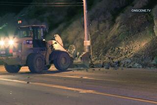
Crews were working to clear rock slides — including one that involved a boulder and a vehicle and left one person injured — on Malibu Canyon Road. Authorities said the road would be closed in both directions from Civic Center Way to Piuma Road at least until Thursday morning.
About 35 people were injured in the collision in the Cajon Pass, which closed the southbound lanes of Interstate 15 near Oak Hill Road in Hesperia for nearly three hours Wednesday morning.
The pileup was reported about 9:20 a.m. and quickly clogged the roadway between San Bernardino and Victorville, according to the San Bernardino County Fire Department.
Fire officials said those involved in the crash suffered minor to moderate injuries, and the majority of them declined to be taken to a hospital. The highway’s southbound lanes reopened about noon, according to the California Highway Patrol.
In Oakland, a man seeking cover under a tree near Interstate 580 was killed when it toppled on him.
“It’s just a tragic incident, just the wrong place at the wrong time,” said California Highway Patrol Officer Herman Baza.
The rain was expected to taper off Thursday afternoon. Unlike the storm that passed through the region Tuesday, the latest round of rain was slow and steady, without the brief bursts of intensity that can sometimes trigger mudslides.
Still, National Weather Service officials issued a flash-flood watch Wednesday for areas near burn scars from fires in the last year, specifically the Woolsey fire burn area, where 300 homes were under evacuation orders. Shallow mud and debris flows are possible near those areas. Authorities in Riverside County also issued evacuation orders in the Holy fire burn area.
Peak rain periods are expected through Thursday morning for San Luis Obispo, Santa Barbara and Ventura counties. Rain should last through 1 p.m. Thursday in Los Angeles County.
The “atmospheric river” storm — a long plume of water vapor pouring over from the Pacific Ocean and swollen with subtropical moisture — is expected to dump from 1½ to 3 inches of rain along the coast in Ventura and Los Angeles counties through Thursday. The foothills could see up to 4 inches of precipitation. Southeast winds of about 15 mph also are expected, said Bonnie Bartling, a weather specialist with the National Weather Service in Oxnard.
This storm was “a little bit different,” Bartling said. It tapped into “subtropical moisture, which means … some decent rainfall and gusty winds off and on.”
Forecasters said the storm also will bring blizzard conditions to the higher elevations of the Sierra Nevada through Thursday, with several feet of new snow and winds topping 50 mph. Heavy snow is also expected for the mountains in Northern California and north into the Cascades.
Ski resorts in North Lake Tahoe saw a couple of feet of snow in the last 24 hours, the weather service reported. Nearly 2½ feet of snow fell in Squaw Valley, while nearby Northstar saw 23 inches.
An additional 3 to 5 feet of snow is expected through Thursday in areas above 7,000 feet, said Scott McGuire, a meteorologist with the National Weather Service in Reno.
“We are in a lull right now, but that is going to quickly change,” he said.
In Northern California, a flood watch remains in effect through Thursday for Butte County, including areas near the Camp fire burn scar. The Butte County Sheriff’s Office issued an evacuation warning for the community of Pulga through Thursday morning.
It has been a wet start to 2019 for the Southland. Downtown Los Angeles has received just over 3 inches of rain this month. Last January, downtown L.A. got 1.77 inches of rain, which is more in line with what is typical for the area, Bartling said.
A flash flood watch remains in effect for a wide swath of Southern California through Thursday, including Orange County and Riverside County mountains and the San Bernardino Mountains. Officials said the potential for mudslides and debris flows exist in recent areas scarred by wildfires, particularly near the Holy fire burn area.
Multiple days of rain have created headaches for commuters from Orange County to the Bay Area.
Pacific Coast Highway closed in Huntington Beach from Seapoint Street to Warner Avenue because of flooding Wednesday morning and was expected to remain cordoned off through Thursday.
In the Bay Area, a small mudslide and a precarious eucalyptus tree joined forces to snarl traffic in Sausalito, north of San Francisco. The mud blocked only one lane of the southbound 101 Freeway in the Marin County town on the northern side of the Golden Gate Bridge, but it exposed the roots of the large tree, which had to be evaluated to determine the risk of its falling onto the highway.
The California Highway Patrol determined the tree did not need to be removed immediately, and all lanes of traffic were opened shortly after.
javier.panzar@latimes.com | Twitter: @jpanzar
hannah.fry@latimes.com | Twitter: @hannahfry
More to Read
Start your day right
Sign up for Essential California for news, features and recommendations from the L.A. Times and beyond in your inbox six days a week.
You may occasionally receive promotional content from the Los Angeles Times.
