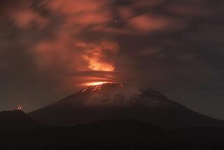
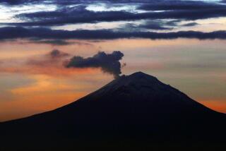
Mt. Pinatubo’s Effects Seen Lasting Years : Environment: Scientists say the eruption may rank with the major volcanic events of history.
WASHINGTON — The eruption of Mt. Pinatubo in the Philippines may rank among the major volcanic events of history, producing atmospheric effects that linger for months, if not years, scientists for the National Oceanic and Atmospheric Administration said Friday.
Satellites tracking the ash cloud high in the Earth’s stratosphere show that material from the explosions is now spread over more than a million square miles, with three distinct “tongues” passing over Africa toward the Atlantic Ocean.
It appears that the Pinatubo event will rank as a very high 5, or perhaps a 6, on the 0-to-8 explosivity scale used to categorize the power of volcanic eruptions. In all of history, there has been no category 8 event and only one category 7--an eruption in Java in the early 1800s. Sixteen eruptions have been ranked as 6s. Mt. St. Helens, which blew up in 1980, was a 5, as was El Chichon, which erupted 400 miles south of Mexico City in 1983.
Because it occurred in the tropics, where the high-speed winds of the stratosphere dip closer to Earth, the effects of the Pinatubo eruption--actually a series of eruptions over several days--are expected to be more far-reaching than they would have been had it occurred at a higher latitude.
NOAA scientists organized working groups Friday in preparation for a continuing study of last week’s eruption and its possible consequences, including the impact on climate and atmospheric ozone.
The El Chichon eruption was followed by changes in the Earth’s weather patterns--a phenomenon known as an El Nino, in which abnormally warm water in the equatorial Pacific provokes a series of events leading to bizarre patterns of drought and rainfall.
Scientific debate still rages over whether a huge volcanic eruption could trigger an El Nino. But Ron McPherson, director of NOAA’s National Meteorological Center at Camp Springs, Md., said he would be reluctant to attribute an El Nino in the coming months to Mt. Pinatubo because NOAA’s Climate Analysis Center, on the day before the eruption, had reported the development of favorable conditions for another El Nino.
So far, there has been no opportunity to obtain samples to determine precisely what substances were injected into the stratosphere by last week’s eruptions. But once the cloud is over the Atlantic, the National Aeronautics and Space Administration is expected to send up one of the nation’s old U-2 spy planes, which are capable of reaching 100,000 feet, to take samples.
NOAA meteorologist James S. Lynch said careful monitoring of Pinatubo began the weekend before the first eruptions because the U.S. Geological Survey had concluded that conditions were favorable for the mountain to explode.
The first major eruption sent ash to altitudes of 60,000 feet. Tracking by satellites both in polar orbit and in synchronous orbit 18,000 miles above the Earth later indicated that significant amounts of ash have reached altitudes of 80,000 to 100,000 feet.
It is believed that much of the gas in the volcano’s plume is sulfur dioxide. But because of the delicate state of the ozone layer in the stratosphere, scientists are anxious to know if the eruption released significant amounts of chlorine compounds.
Chlorine destroys ozone, and its use in refrigerants in this century has done serious damage to the ozone layer, which shields the Earth from ultraviolet radiation associated with skin cancer.
Ordinarily, chlorine would not be expected to be a major product of a volcanic eruption, but it was produced in the El Chichon eruption because there was a huge underground salt dome nearby.
One of the more noticeable aftereffects of the eruption in Mexico was a string of spectacular sunrises and sunsets all over the world for a period of years--caused by the ash that continued to travel around the Earth in the stratosphere.
Although the El Chichon ash cloud has thinned out to the point that it is no longer visible, satellites are tracking it with the same instruments that have been used in recent months to measure the content of ozone in the stratosphere.
With the first eruptions from Mt. Pinatubo on June 12, NOAA scientists alerted commercial airlines to the projected course of the ash.
Once in the stratosphere, the ash cloud was carried southwest across the Indian Ocean, and continues to move at 65 to 80 knots. The main concentrations are now reported to be over equatorial Africa and the Arabian peninsula.
As expected, the Indian Ocean produced a huge gap in the assembly of scientific data. Although India has a geosynchronous satellite looking down on the Indian Ocean, the government considers it a national security asset and refuses to share its full output with other nations.


