Storms Perk Up Falls in Trabuco
The rain came down in Orange County for two straight weeks--or so I heard.
I missed most of the storm, showing great prescience in planning my vacation, and when I got back into town, the sun was shining and the county was drying out. I knew it would be a great time to catch some of the storm’s aftermath: the rebirth of our backcountry streams and waterfalls.
Through seven years of drought, the streams of the Santa Ana Mountains have been pretty dry, coming to life only briefly after the few sporadic storms we have had. This year, with rainfall above the seasonal average, brooks are babbling in every canyon.
I decided to head for Holy Jim Falls, a hike of 2.8 miles (round trip) from the trail head on Trabuco Creek Road. The 20-foot cascade is probably the county’s best-known waterfall, and while it’s no Niagara or Yosemite, it is a nice little splash of wilderness set amid oaks and sycamores and other native greenery.
That’s the way I remember it, at least, from a visit a few years back. I wasn’t able to reach it this time, mostly because Trabuco Creek was as close to raging as it ever gets, and it crosses rocky, unpaved Trabuco Creek Road numerous times. Under normal conditions, a passenger car can make (albeit slowly) the 4.7 miles to the Holy Jim trail head without too much trouble--but these weren’t normal conditions.
Trabuco Creek Road departs from Live Oak Canyon Road in Trabuco Canyon, not far from the stucco sprawl of Rancho Santa Margarita in miles but light-years away in its laid-back, rural feel. (Live Oak Canyon Road, which passes beneath a canopy of oak branches, is my candidate for prettiest drive in the county.)
I went on the first Sunday after the rains stopped. The road goes up-canyon as it follows the creek, which was roaring. Driving my small pickup gingerly along the rutted road, I forded several small side streams before crossing the creek itself on a concrete spillway, where the water rushed above my axle.
After less than two miles, my drive came to a stop. A low section of road, still muddy from the rains, had become a playground for an assortment of yahoos in their big four-wheel-drive toys. Their idea of great fun was churning back and forth through the 25-foot stretch, tires spinning and mud flying, until the road was an impassable bog, at least for me. I parked and continued on foot.
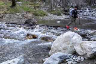
Even walking, the road was an adventure, as I had to cross side streams twice on fallen logs and ford the main stream once, taking off my boots and walking through chilly, fast-moving water that splashed above my knees. Not long after that, I accepted a short ride from someone who told me that the water the week before had been much higher; he also told me about another waterfall in a side canyon that I had not hiked before. I decided to try it.
Some hikers I met told me the apt name: Falls Canyon. The trail head is about three miles along Trabuco Creek Road, at a point where the road is about 25 feet above the stream (on the left) and also where the road widens to allow parking on the right. There’s no sign, so stay alert.
Several small trails head down the bank to where the side stream from Falls Canyon joins the main body of Trabuco Creek, which you’ll have to cross (either on a log, or by fording the stream on foot). The trail starts on the right side of the stream and crosses it several times as it climbs up the canyon--it can be easy to lose, but just stay close to the stream and you’ll find it again.
The canyon here is narrow and fairly steep, and the walk is moderately strenuous in spots. It’s a beautiful hike, densely wooded, with lots of brilliant-green new grass, thanks to the rain. There are even a few wildflowers out now, although the real show will come in spring.
(Warning: The brushy green stuff with serrated leaves that grows in little bunches of three is poison oak. Steer clear).
After about 15 minutes of walking, a small stream cascades down from a side canyon on the left into the main Falls Canyon. This isn’t the waterfall you’ve been looking for; continue up-canyon (picking your way over a large fallen tree) for another 10 minutes or so.
The waterfall is a pretty good one for our local hills, falling 25 feet or so in one straight leap from the lip of a sheer cliff. It’s a good place to break out that sandwich and have a swig of water from your bottle (don’t drink from the stream, no matter how much it looks like something from one of those bottled-water commercials--you could end up with giardiasis). Then head back along the same trail.
Unless it rains more, getting to the trail head for Falls Canyon will be a lot easier by the time this story hits print. The road will be drier, and the streams will have subsided some, although the falls will still be flowing enough to make it a worthwhile trip.
It should be possible for a passenger car with decent clearance to get to the trail head for Holy Jim Falls now, too. A parking lot for the trail head is on the left, 4.7 miles along Trabuco Creek Road from the turnoff on Live Oak Canyon Road.
An alternate way to enjoy Trabuco is to park at the beginning of the dirt road and ride a mountain bike into the canyon. Take a lock and stow your bike at a trail head if you want to walk to one or both of the waterfalls.
The following description is adapted from Jim Schad’s handy guide, “Afoot and Afield in Orange County” (Wilderness Press): Walk up the road that branches north along the east bank of the stream for half a mile, where you find a steel gate. Beyond the gate, a narrow trail heads upstream, crossing the stream several times in the next seven-tenths of a mile.
After the seventh stream crossing, the trail switches back to the left and begins climbing the west slope of the canyon. Leave the main trail here and continue straight along the bottom of the canyon on a narrow, ill-defined trail. After about 400 yards, you’ll come to the base of the falls.
Head back along the same trail; the whole walk is a little less than three miles, or about 90 minutes of walking.
What: Waterfall hikes in Trabuco Canyon (Falls Canyon and Holy Jim Falls).
When: Anytime during daylight.
Where: Trails depart from Trabuco Creek Road in Trabuco Canyon.
Whereabouts: From Interstate 5, take El Toro Road north several miles to Live Oak Canyon Road, a right turn at the landmark Cook’s Corner roadhouse. Follow Live Oak Canyon for a few meandering miles until you pass Rose Canyon Drive on the left. Trabuco Creek Road is an unmarked dirt road on the left, within 100 yards. See story for trail-head details.
Wherewithal: Free.
Where to call: (714) 728-0113.
*
* RECREATION LISTINGS, Page 36.
More to Read
Sign up for The Wild
We’ll help you find the best places to hike, bike and run, as well as the perfect silent spots for meditation and yoga.
You may occasionally receive promotional content from the Los Angeles Times.


