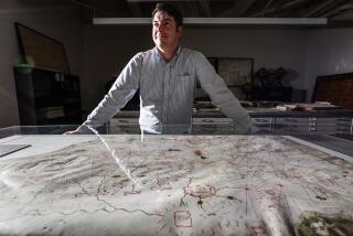
Cartographer Follows Twists and Turns of Evolving Landscape
- Share via
If keeping track of all the streets, freeways and assorted byways was all Larry Bakke had to do for a living, life would be relatively simple.
But newly constructed roadways are only a single layer of the ever-changing strata of information that Bakke must collect as a modern-day cartographer at Thomas Bros. Maps, makers of the ubiquitous Thomas Guide map books that are responsible for most of the $25 million in sales projected for the West Coast company this year.
Besides the “transportation layer,” there are information layers for waterways, for city and county boundaries, parks and preserves, major shopping centers and fairgrounds, colleges and military bases.
There is also what Bakke calls the layer of cultural features, which includes museums and amusement parks, prominent buildings and hotels, historic sites and transportation hubs.
Anything of significance in a community is collected and considered for inclusion on the map. And any time anything changes--a freeway with a new name, a hotel that goes out of business, a new toll road or new plans for an international airport--Bakke and his co-workers need to know. It’s a lot to keep up with.
“You’ve got new roads, changes in names, city boundaries extending out, new points of interest that are opening all the time and points of interest that close or move. All the layers of information are constantly changing,” said Bakke, a 39-year-old Santa Ana resident.
“Our sources really have to be good. Through our constant updating, we have built solid contacts with all the different agencies and organizations. We’re constantly calling them, and many of them are calling us to make sure we get the updated information.”
*
Sources of information range from county tract maps to local chamber of commerce officials. And all new information has to be confirmed by multiple sources before changes in the maps are made.
Bakke’s fascination with maps began at an early age when he plotted routes and suggested points of interest to his parents during family vacations. While earning a university degree in geography, he worked for a Santa Ana delivery service. He quickly advanced to the position of dispatch supervisor, in which he plotted the quickest routes for delivery drivers to follow.
When Bakke joined Thomas Bros. at its Irvine headquarters in 1984, map-making was still very much a pen-and-ink affair.
Master maps first were created on paper, then copied onto a clear plastic sheet of Mylar for photographing and printing. As a junior-level cartographer, Bakke’s job was to update the Mylar maps, copying additions and revisions from a paper map placed underneath the clear plastic.
*
In 1988, the company began transferring its master maps into digital form for production of the map guides and a host of new computer-based products.
“We were starting with totally different sources of data. We had to take this raw digital data and get it into a format that looked like the traditional Thomas Guide, which meant cleaning it up, checking the information and making sure whatever was in the old guides got into the new guides.”
The Sacramento Thomas Guide was the first to be converted to a computer database. It took nearly two years to create a reliable network of source information that could be transferred to the company’s computers, and another two years to complete the changeover, said Bakke, who has been one of the company’s digital conversion supervisors since 1993.
During the last few years, he has had the daunting task of working with colleagues to establish information sources for the company’s new map guides in the Washington, D.C., Maryland and Virginia areas. They represent the 82-year-old company’s first expansion beyond the West Coast.
“We started with new sources of information that had different levels of accuracy and completeness. We had to take all that and make a Thomas Guide out of it. We’re learning as we go. We’ll probably find out a lot more when we get feedback on that first product back East. People are going to call in, give their opinions, and we’ll take that information and decide what is valid and what should be reflected in the next updated map guide.
“People like updated maps, and they also like to tell us when we’ve made a mistake. It’s not like we’re wrong all the time, but it takes a lot of information to create a map. Things are changing too quickly to be able to create the perfect map. It’s impossible.”
(BEGIN TEXT OF INFOBOX / INFOGRAPHIC)
Profile: Larry Bakke
Age: 39
Hometown: Fountain Valley
Residence: Santa Ana
Family: Single
Education: Bachelor’s degree in geography from Cal State Long Beach
Background: Dispatch supervisor for Advanced Delivery Service, Santa Ana, 1979-84; joined Thomas Bros. Maps in 1984 as a cartographer, became a supervisor in the digital conversion department in 1993; has helped oversee the transfer of map data to computers; is one of the supervisors responsible for establishing information networks for the company’s new map guides in the Washington, D.C., Maryland and Virginia areas
On keeping current: “To create an accurate map takes a lot of information, and things are constantly changing. . . . We have built a network of source contacts with all the different agencies, but it’s a constant battle to keep up with all the changes.”
Source: Larry Bakke; Researched by RUSS LOAR / For The Times
More to Read
Sign up for Essential California
The most important California stories and recommendations in your inbox every morning.
You may occasionally receive promotional content from the Los Angeles Times.


