Devil of a Good Time at the Punchbowl Park
Here’s a suggestion for Valley folk looking for an easy but memorable jaunt to occupy the interest of kids and visiting kin during the holidays: Visit Devils Punchbowl County Park on a Sunday this month.
That’s when veteran park ranger Dave Numer conducts an hourlong “geology tour” at 1 p.m. It’s a quick and vivid way to learn of the secrets deep inside the Earth. And this time of year--when skies are clear and the desert is cool--is one of the best times to visit the Antelope Valley, where the park is located.
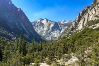
Last Sunday, Numer began his tour at the park’s Nature Center overlooking the spectacular bowl-shaped canyon for which the place is named. With arms outstretched, palms up, he used each hand to represent a tectonic plate shifting on the Earth’s surface.
“Mountain ranges rose up here when the plates collided,” Numer said, using his hands to describe the geologic forces at work. “This bowl-shaped canyon was formed as boulders and water flowed off the mountains during the last 13 million years.”
On another part of the tour, visitors drove behind Numer’s ranger truck to inspect several sites just outside the park’s borders. “See there where the top of the hill has red earth and the bottom is yellow--where one continental plate forced its way up and over the other--that’s the San Andreas fault,” Numer explained at one spot. He marked a place in the sand and invited folks to stand with one foot on each side of the famous fault line.
At another location, he took us to a spot where earthquake researchers had dug a trench to expose an underground section of the San Andreas fault. “This is where the National Geographic filmed their television documentary, ‘Born of Fire.’ It’s available in the video stores,” he said.
Park visitors can also visit the natural history display at park headquarters, or explore the hiking trails. There’s also a picnic area, but no food service.
To get to Devils Punchbowl from the Valley, take the Golden State Freeway (5) north to the Antelope Valley Freeway (14). Get off at the Pearblossom Highway exit, turning left, and follow the signs to the Pearblossom Highway (Route 138). Continue to County Road N6, take a right and drive seven miles. Look for the Lewis Ranch sign, turn left and continue to the park.
The canyon’s name originated with the early Native Americans of the area, who believed the place was inhabited by mountain lion demons. Numer, who has worked at the park 23 years, said, “We’ve never had a mountain lion attack in this area.” The occasional late-night howling of the big cats, however, might conjure up devilish images.
Devils Punchbowl County Park and Nature Center, open sunrise to sunset daily, ranger-guided geology tour 1-2 p.m. Sundays, 28000 Devil’s Punchbowl Road, Pearblossom (Antelope Valley). Day parking fee is $3. Information, (805) 944-2743.
More to Read
Sign up for The Wild
We’ll help you find the best places to hike, bike and run, as well as the perfect silent spots for meditation and yoga.
You may occasionally receive promotional content from the Los Angeles Times.


