Why the ‘extreme red flag’ winds hitting L.A. region are especially dangerous

- Share via
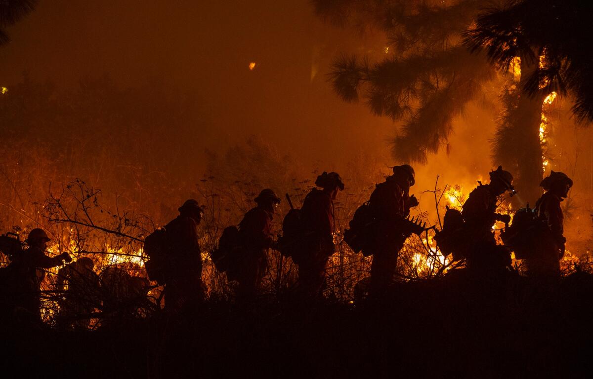
Even after several years of devastating wind-driven fires in Southern California, forecasters fear that the next two days could bring new levels of danger.
“Extreme” fire weather began in the Los Angeles area at 11 p.m. Tuesday and was expected to persist for 30 hours, bringing isolated gusts of up to 80 mph. It’s an unusually long Santa Ana wind condition, and fire weather of this kind hasn’t been seen in Southern California since October 2007, when similar conditions helped unleash the sixth most destructive fire in California history.
The National Weather Service office in Oxnard took the unusual step of labeling the fire weather conditions an “extreme red flag” warning, a term that meteorologists there say they can’t remember ever using. But they did so to underscore the severity of this Santa Ana wind event.
“This is the worst since we had an event in October 2007,” said National Weather Service meteorologist Tom Fisher. “Don’t let your guard down.”
“It’s going to be stronger than most Santa Ana conditions, in terms of the raw wind speed, and the long duration of the winds,” and the particularly dry air, said weather service meteorologist Joe Sirard.
“It’s kind of like when your skin starts to crack open — it’s going to be that kind of dryness,” Sirard said. “Very, very dry air coming in.”
Here is what we know:
The forecast
Dangerous winds are forecast to blow so hard that there’s a threat of downed power lines. Mountains could see gusts of up to 80 mph; valley passes, canyons and coastal areas between the Hollywood Hills to Malibu and the Ventura County coasts could see gusts of up to 60 mph.
The wind speeds from the extreme red flag warning event that started Tuesday at 11 p.m. and was to last through Thursday at 6 p.m. could produce damaging sustained winds of 50 mph to 70 mph across most of L.A. and Ventura counties, with isolated gusts of 80 mph; the air moisture will be dangerously dry, with relative humidities falling to perhaps 1% or 2%; a humidity of 15% to 20% is already quite dry.
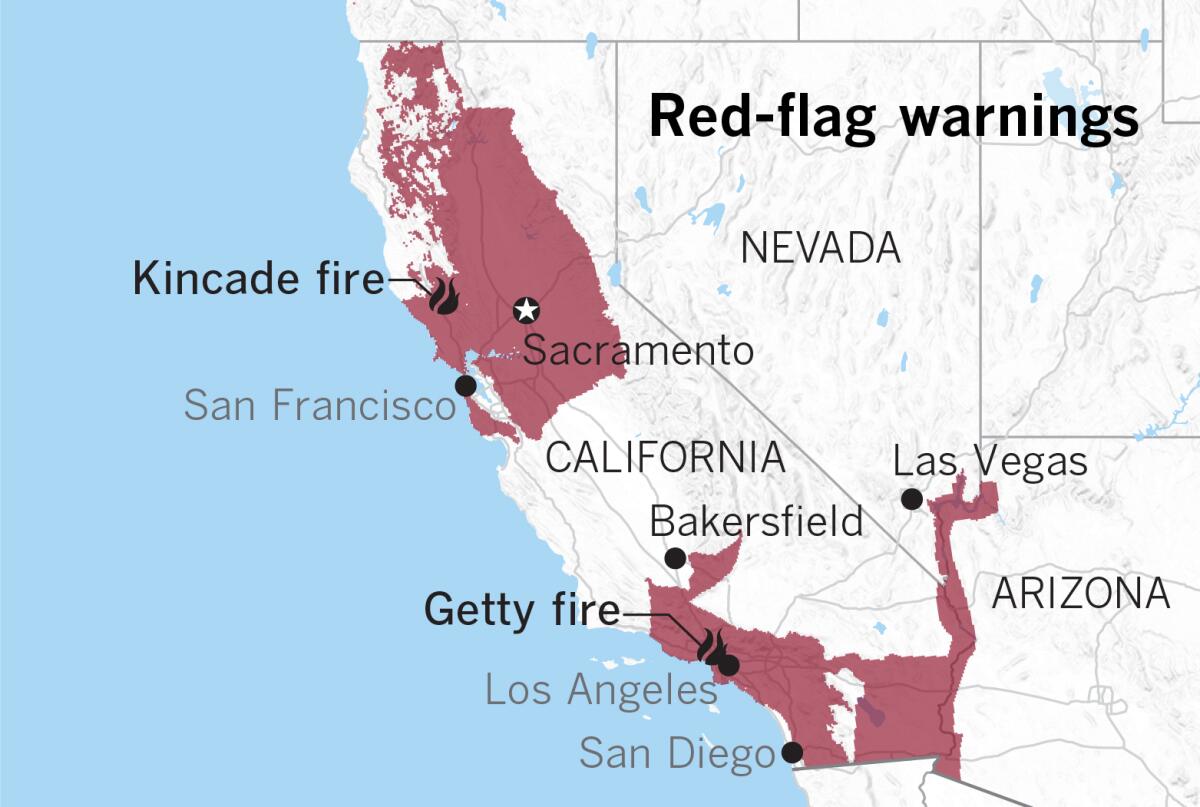
Red flag warnings will be in effect starting either Tuesday night or Wednesday morning in Orange, Riverside, San Bernardino and San Diego counties.
“This all adds up to an extreme fire weather threat, meaning that conditions are as dangerous for fire growth and behavior as we have seen in recent memory,” the weather service in Oxnard said.
Exceptionally dangerous conditions
Red flag warnings — a term to warn of high fire weather danger — are already supposed to spark alarm bells for the general public. But this one is on the higher end of any similar period of fire weather in the past dozen years.
In October 2007, a series of fires broke out across Southern California, burning more than 198,000 acres, destroying 1,500 homes, injuring 40 firefighters and causing two deaths. The most significant of those fires was the Witch fire in San Diego County, which destroyed more than 1,000 homes and ultimately caused the region’s major utility to launch a $1.5-billion effort to harden its grid that is still going on.

“It’s not a routine red flag warning event. It’s on the high end of the scale, in terms of weather significance,” said Sirard. “We want to emphasize the exceptional danger of this type of event.”
The wind speeds could be comparable, or even stronger, than the Santa Ana winds that whipped the Thomas fire to grow at a breathtakingly fast pace in December 2017 in Ventura County and eventually burn into Santa Barbara County.
Strong winds slapped together two Southern California Edison power lines together that month, igniting the Thomas fire, which killed two, destroyed more than 1,000 structures and burned more than 280,000 acres. That fire is California’s 10th most destructive in the modern record.
What’s causing the extreme conditions
The Santa Ana winds of Southern California come from the northeast and blow southwest, fueled by high-pressure air over Nevada and Utah seeking a path through mountain slopes and canyons to fill lower-pressure voids on the coast. Not only is dry desert air blowing into California, but as the air descends in elevation it warms, and the relative humidity plummets.
One tool forecasters use to predict Santa Ana winds is to measure the difference in pressure between Los Angeles International Airport and the community of Daggett in the San Bernardino County desert. The record for October — which sees particularly flammable vegetation if autumn rains haven’t yet arrived — is negative 10.2 millibars, which occurred on Oct. 21 and Oct. 22, 2007. On Oct. 21, 2007, San Diego Gas & Electric’s downed power line started the Witch fire, burning nearly 200,000 acres.
The forecast for this extreme red flag event is negative 10 millibars. That’s why forecasters are so concerned this event may be extreme.
The monster Santa Ana event is being fueled in part by intensely cold high pressure over the Rocky Mountains.
“There’s actually record cold air mass right now over the Rockies and the Great Basin,” said Daniel Swain, climate scientist with UCLA and the National Center for Atmospheric Research. In Boulder, Colo., there’s a foot of snow on the ground and the temperature is 9 degrees — in October.
“This extremely cold air mass directly from the Arctic is sitting just to the east of California. And that is obviously a great contrast with the not-so-frigid air over California, and especially as you get closer to the ocean,” Swain said. “That thermal contrast is setting up that strong pressure contrast, which is in turn driving these very strong winds.”
While temperatures along the California coast are close to average for this time of year, they’re well below average to the state’s east — an extreme difference that’s driving the winds, Swain said.
The air mass “dropped straight down southward out of the Arctic over the Rockies because there’s such a big mass of high pressure over Alaska right now, where they have been experiencing record warmth on a recurring basis, and where there is effectively no sea ice on the Arctic Ocean coast for the first time in recorded history in October.”
The warm mass of air over Alaska, as a result, has had the effect of placing “a big blob of cold air over the Rockies, which is creating this extreme contrast that’s generating the winds in California,” Swain said.
Strong winds in unlikely places
A danger for Southern California is that places that don’t often see strong winds could see them. Parts of the San Fernando Valley could see gusts of 70 mph to 80 mph.
“The magnitude of the wind gusts really are going to be a concern,” Swain said. “The actual winds that people experience really will be quite extreme in a lot of places, really everywhere except for the wind-sheltered parts of downtown L.A. and central L.A.”
Swain said this Santa Ana event won’t be as long as the Thomas fire’s in 2017, which lasted for days. But it will feel long, considering how extreme the winds will be, Swain said. “It’s not going to be a quick, six-hour-over-and-done sort of thing. It’s going to be at least a 24-, 36-hour duration of extremely strong winds in a lot of places.”
Northern California also hit
The National Weather Service office in Monterey, which covers the Bay Area, forecast a “historic” and “extreme” Diablo wind event for this past weekend, and their forecast was right. Strong winds aided the rapid spread of the Kincade fire in Sonoma County over the weekend, where a gust of 96 mph was recorded in the Mayacamas Mountains northeast of Healdsburg. Firefighters fought rapidly growing fires on both sides of the Carquinez Bridge and in the cities of Lafayette and Martinez in the East Bay.
Large swaths of Northern California are also under a red flag warning that began Tuesday and will last through Wednesday. Dry, gusty Diablo winds from the northeast won’t be as strong as they were over the weekend, but they could still hit 65 mph in the North Bay mountains; in the East Bay mountains, 50 mph; and in the Santa Cruz Mountains and the peninsula south of San Francisco, 40 mph.
Using the word ‘extreme’
The National Weather Service has begun to use the word “extreme” to characterize other potentially catastrophic weather events differently, such as for flash flood warnings and tornado warnings, Swain said.
“In places where both of those are common, like the Deep South for floods and ‘Tornado Alley’ in the Midwest for tornadoes, people started to dismiss regular old tornado warnings and regular old flash flood warnings,” Swain said. “So they started to issue a ‘flash flood emergency,’ or ‘particularly dangerous situation’ tornado warnings, sort of as a signifer that this was no ordinary flood, or no ordinary tornado.
“It sounds like we’re starting to use the same kind of language now for fire weather warnings in California,” Swain said.
More to Read
Sign up for Essential California
The most important California stories and recommendations in your inbox every morning.
You may occasionally receive promotional content from the Los Angeles Times.


