High temperatures will continue across Southern California on the heels of two winter fires


Super Bowl Sunday is going to be hot — and not just because of the matchup between the Rams and the Bengals.
Hot, dry conditions that helped drive a pair of Southern California fires on Thursday will continue through the weekend before giving way to a dramatic cooling, officials with the National Weather Service said.
Temperatures are expected to hover in the 80s in the burn areas in Los Angeles and Orange counties, with some gusting Santa Ana winds.
“Probably not record-breaking temperatures but certainly well above normal temperatures” for this time of year, said John Dumas, a meteorologist with the weather service’s Oxnard station.
Neither blaze is an active threat, according to fire officials. But their arrival during the height of winter wasn’t overlooked.
“We no longer have a fire season. We have a fire year,” Orange County Fire Authority Chief Brian Fennessy said Thursday. “This is supposed to be the middle of winter, and we’re anticipating 80- to 90-degree weather. Even though the hillsides are green, it doesn’t take but low humidity and wind to cause fires to occur.”

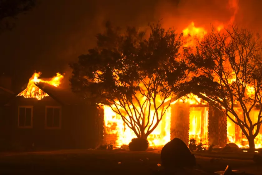
Two fires, one near Laguna Beach and the other near Whittier, brought harbingers of a difficult fire year for the parched region.
The Sycamore fire broke out about 3 p.m. Thursday near Whittier and destroyed two homes and injured one person before it was fully contained, said Isaac Rivera, a spokesperson for the Los Angeles County Fire Department.
On Friday, a man was arrested on suspicion of arson in connection with the blaze that charred seven acres, according to the Los Angeles County Sheriff’s Department.
In Laguna Beach, the Emerald fire erupted about 4 a.m. Thursday, authorities said. As of Friday night, it had burned 154 acres and was 60% contained.
Crews worked overnight on the interior of the fire, putting out hot spots. On Friday, the focus was shifted to creating containment lines around the perimeter, said Capt. Paul Holaday, a spokesperson for the Orange County Fire Authority.
“We feel comfortable that the forward spread of the fire is over,” Holaday said.
Personnel are expected to continue battling the blaze through the weekend. About 185 firefighters are assigned to the fire as of Friday night, said Capt. Steve Concialdi, a Fire Authority spokesman.
A vegetation fire that broke out Friday afternoon near 52nd Avenue and Fillmore Street in Coachella was holding at roughly 10 acres by nightfall, according to the Riverside County Fire Department. Crews were expected to remain on scene battling the blaze overnight.
More wind is anticipated over the weekend, but it will be weaker than the strong gusts that fanned the blazes, said Samantha Connolly, a meteorologist with the National Weather Service’s San Diego station.
Though that’s good news for firefighters, it still carries some risk.
Connolly said the strongest winds would arrive Friday night and last through Saturday morning, topping out at about 15 to 20 mph near the burn area.
“The winds aren’t looking super strong, but they will be coming out of the east, which will bring in drier air to the [Emerald] fire area,” Connolly said.

The Sycamore fire broke out Thursday afternoon in the 4800 block of Cinco View Drive near Whittier.
Despite the unsettling fire risk brought by high heat and low humidity, Dumas said the likelihood of rapid fire spread is low.
He said fire agencies have conveyed that fuel beds are still moist enough to prevent explosive growth that can occur when a fire starts and vegetation is dried out.
Frequent warm Santa Ana winds combined with a high pressure system over the region has contributed to the summer-like conditions, Dumas said.
“We’ve just had Santa Ana event after Santa Ana event,” he said. When the wind travels from the east, down through canyon passes, “it warms up and that warms us up.”
But a big change is in store for the Southland beginning Monday.
A relatively strong low pressure system will make its way down the coast to Southern California, bringing markedly cooler temperatures and even the possibility of rain.
Temperatures could plummet to the 60s, with a chance of rain on Tuesday.
While that’s welcome news for the region — which hasn’t seen much precipitation following a series of powerful December storms — weather officials said any rain that arrives will be light. February is traditionally the wettest month of the year, but so far there has been little of it.
Dumas said there’s about a 30% chance of about one-tenth of an inch of rain in the Los Angeles County area.
Times staff writer Gregory Yee contributed to this report.


Sign up for Essential California
The most important California stories and recommendations in your inbox every morning.
You may occasionally receive promotional content from the Los Angeles Times.