California lowering dam water levels, warns of flood threat as storm hits
- Share via
With back-to-back storms to hit California in the coming days, state officials are scrambling to make strategic releases from key reservoirs in hopes of preventing a repeat of the flooding that killed nearly two dozen people in January.
At least 10 rivers are forecast to overflow from the incoming “Pineapple Express” storm, which is expected to drop warm, heavy, snow-melting rain as it moves from the Central Coast toward the southern Sierra beginning Thursday night into Saturday.
Among them are rivers that flooded at the start of the year, when nine atmospheric river storms pummeled the state. The waterways include the Cosumnes River near Sacramento, where more than a dozen levee breaches sent floodwaters onto roadways and low-lying areas, trapping drivers and contributing to at least three deaths along Highway 99.

“This is a very dynamic system,” Department of Water Resources director Karla Nemeth said at a briefing Thursday. “Rivers and creeks can rise very quickly, and so it does have the potential to be a dangerous situation, particularly in areas that had experienced flooding before.”
Officials activated the State-Federal Flood Operation Center on Thursday morning, Nemeth said, which indicates an elevated level of coordination and monitoring before the storm.
Yet another atmospheric river is expected to follow early next week, and there is a potential for a third around March 19, according to state climatologist Mike Anderson.
“We were well on our way to a fourth year of drought” at the beginning of January, Anderson said. “We’re in a very different condition now.”

‘A potentially significant and very likely warm atmospheric river event’ is set to hit California later this week, forecasters say.
The incoming storm will fall atop soaked soils and some of the deepest snowpack California has recorded. Both can exacerbate the potential for runoff and erosion.
The conditions are in some ways akin to those that led to a near catastrophic failure of the Oroville Dam in 2017, when heavy rains damaged an emergency spillway and threatened to send floodwaters down to communities below.
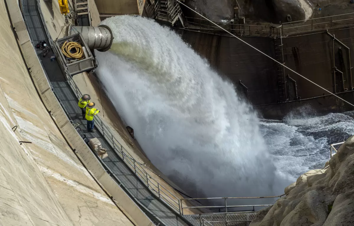
Officials on Thursday said there is no danger of a similar event now since the spillway has been reconstructed with several feet of thick concrete. However, the second-largest reservoir in California is about 60 feet below its maximum elevation, said Ted Craddock, DWR’s deputy director of the State Water Project, and operators have begun releasing water to ensure room for incoming flows.
Increased releases from Oroville’s Hyatt Power Plant started Wednesday, Craddock said, with more to begin Friday from its gated spillway at a combined rate of 15,000 cubic feet per second from both facilities. It will mark the first use of the main spillway since April 2019.
“This is a relatively small release out of the spillway, and as we look further into the forecast, with the possibility of additional storms, we will be adjusting releases from the lake,” Craddock said.

As yet another atmospheric river barrels toward California, residents brace for the threat of engorged rivers and overtopped reservoirs.
Officials from the DWR, the U.S. Bureau of Reclamation and the U.S. Army Corps of Engineers are also ramping up releases at other locations before the storm, including Lake Shasta and Millerton Lake, said Levi Johnson, deputy operations manager of the Central Valley Project with the Bureau of Reclamation.
Folsom Lake — which primarily acts as a flood control system for the Sacramento area — still has “quite a bit of storage space,” Johnson said, but officials are anticipating flows there will increase with the current storms. Releases went up to about 15,000 cubic feet per second Thursday, and then will increase to 30,000 on Friday.
“These releases are in anticipation of the inflows due to these storms,” Johnson said. “We will be prepared to increase further if needed and as we see how the inflows from these storms shape up.”
Despite assurances, some people in the Central Valley said they’re concerned about the risks of devastating floods in the coming days.
“I am fearing levee failures and flooded homes,” said John Ennis, a civil engineer who owns a consulting firm in Fresno.
Ennis said he’s worried that “there’s just going to be too much water on top of the snowpack, and it all dissolves at once” — a scenario that could send floodwaters roaring down from Sierra Nevada into the Central Valley.
Anne Lynch, integrated water management lead with the consulting firm GHD, said it’s good news that the state’s reservoirs are being actively managed for flood control, especially in areas that saw flooding previously.
“They’re managing for our water supply, which has also got to be front-of-mind, but they’re also managing for the ability to not have reservoirs overtopping,” she said. “It’s a complicated thing.”
Some areas that flooded during the previous storms, such as Wilton, are “natural flow areas” that almost always flood during heavy rains and are likely to flood again, Lynch noted. Although some incidents are inevitable, she said, such events are also reason to invest in infrastructure.
“There’s the things that are outside of our control, and then the things that haven’t been built,” she said.

The brunt of the warm storm is expected to hit Northern and Central California late Thursday and into Friday, but Southern California will feel some effects as well.
In high-elevation areas, the biggest threat from the storm will probably be structural damage as rain makes the snowpack even heavier, UCLA climate scientist Daniel Swain said during a briefing. The state has seen a spate of roof collapses from heavy snow, including a grocery store providing crucial supplies in Crestline.
“The bigger concern with flooding is actually at lower to medium elevations,” Swain said. That includes areas at about 5,000 feet and below in Central California and the southern Sierra.
“There really will be significant melting of the snowpack — which is substantial at those elevations — as heavy rain falls into it,” he said. “But really, the main flood threat is coming from the fact that the storm is just going to bring a significant amount of rainfall in its own right.”
According to the National Weather Service, some of the highest flood risk will be in coastal areas from Salinas to San Luis Obispo, and throughout the Central Valley.
Officials in Fresno, Madera, Modesto and Santa Cruz counties have issued evacuation warnings for some communities due to likely flooding. San Luis Obispo County, which saw significant flooding during the January storms, has the “potential for similar impacts” from the incoming system, the weather service said.
Crews are “battening down the hatches and getting ready for the storm series,” said Mark Bingham, fire protection district chief in the Santa Cruz mountain town of Boulder Creek. “We’re hopefully ready for what Mother Nature throws at us.”
In the Merced County town of Planada, officials went door to door to many homes Wednesday and Thursday to warn of possible disaster. The town was almost entirely flooded after a levee broke in January.
“People are full of fear,” County Supervisor Rodrigo Espinosa said from his car as he returned from watching crews lay sandbags at nearby Bear Creek. He hoped that the sandbags, debris clearance and other infrastructure improvements would prevent a worst-case scenario.

After the town flooded and about half its homes were damaged, residents of this farming community struggle to find temporary housing and rebuild.
Swain said that some effects of the storm may not be felt right away, but that the state’s heavy snowpack “is all going to have to come downhill eventually.”
“Even though the flood peaks don’t look extremely high on any individual river system with this event, what’s going to start to happen is we’re going to see now elevated flows on a lot of major rivers for a very prolonged period of time — so not just for hours or even days, but very possibly more like days to weeks or longer,” he said.
Adding to the challenge are increasingly unpredictable patterns driven by climate change, as well as the difficulties of securing funding for flood control projects in an often bone-dry state, said Lynch, of GHD. Warm rain-on-snow events and other extreme weather can upend the natural timing of snowmelt that state water managers have long relied on.
“The amount of snow we got this year was awesome, but it has its own challenges for the system, because we designed it and built it for one kind of reality, and we’ve got a changing reality that we’ve got to move to address,” she said.
Ennis, the Fresno resident, works with developers and farmers and said he’s concerned about potentially dangerous circumstances, including sudden levee breaks that could put people at risk.
“There’s only one thing that keeps me up awake at night as a civil engineer, and it’s water. It’s this kind of situation,” he said. “You’re potentially talking about insane volumes of water.”
Times staff writers Jessica Garrison and Susanne Rust contributed to this report.


Sign up for Essential California
The most important California stories and recommendations in your inbox every morning.
You may occasionally receive promotional content from the Los Angeles Times.


More From the Los Angeles Times


Podcasts

In this episode, we discuss the history here, what lessons were learned — and not — and how that can inform what we we do this time around as we attempt to rebuild Altadena and the Pacific Palisades.

This week’s episode covers the sentencing and future legal proceedings for “The Ketamine Queen” — the doctor who pled guilty to supplying Matthew Perry with ketamine.

This week, “A Matter of Degrees,” hosted by Dr. Leah Stokes & Dr. Katharine Wilkinson, discuss how insurance companies are failing to accommodate for the impacts of climate change.


