Big Sur’s Highway 1 to reopen Friday — ahead of schedule — after major rockfall

- Share via
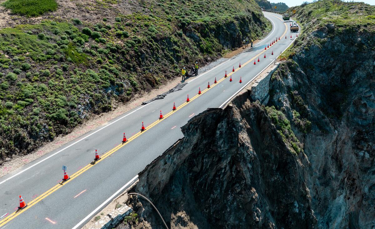
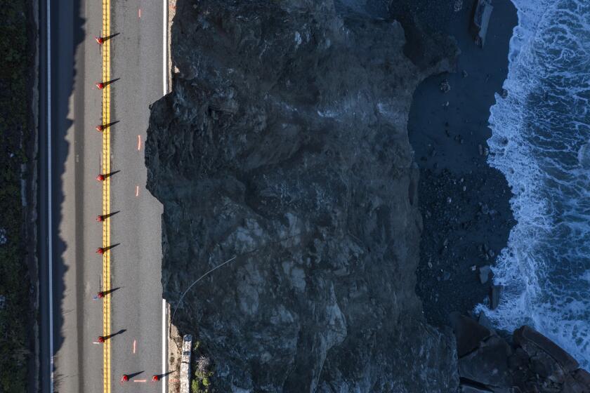
Along an almost 40-mile stretch of Highway 1, Big Sur has been isolated from the rest of the state for weeks — with limited access for residents and essential workers — after a massive chunk of the roadway fell into the ocean in late March.
But on Friday — ahead of schedule — the damaged section of the scenic highway will reopen to the public, via an alternating single lane, Gov. Gavin Newsom announced Tuesday at a news conference. The reopening, following major repairs and remediation completed under arduous conditions, restores access to several tourism hot spots along the roadway.
“Caltrans is working overtime,” Newsom said. “Subject to an act of God, extreme winds, unlikely rain … we’ll be able to achieve that: 6:30 [a.m.] this Friday, Highway 1 will be reopened.”
The California Department of Transportation had previously committed to reopening the section of damaged highway by Memorial Day.
Wet winters accelerate damage along the vulnerable Big Sur coast. But repairs should allow Highway 1 to partially reopen by Memorial Day.
The iconic route has been closed to the public since March 30, when torrential rains pounded the coast and a section of the southbound lane near the Rocky Creek Bridge collapsed, about 12 miles south of Carmel.
Officials have been working to confirm stability and restore access to the area using only the northbound lane, as it wasn’t damaged when the rockfall took a bite out of the southbound lane. Caltrans plans to use traffic signals to alternate vehicles traveling in both directions across the single lane, allowing for 24/7 traffic.
Newsom on Tuesday acknowledged the “deep anxiety” that residents and business owners had felt the last few weeks, coming and going only through twice-a-day convoys, which were canceled a few times due to weather concerns. The local chamber of commerce had urged expedited repairs to help avoid further losses during one of Big Sur’s peak seasons for tourism, the area’s largest industry.
The closure from the March slip-out was particularly challenging because access to much of Highway 1 had already been limited to travelers coming from the north, as a different stretch of the roadway has been closed since January 2023. About 30 miles south of the Rocky Creek slip-out, a string of landslides — including one this winter — closed about 12 miles of the roadway near Lucia. That closure begins near Limekiln State Park in the south.
Repairs there remain ongoing, and officials have said they hope to reopen that stretch sometime this summer.
Caltrans has shut down the southbound road on Highway 1, letting only essential workers and locals through on the northbound side.
At the Rocky Creek closure, crews have been working since March — often suspended in a basket from a crane above the 200-foot ocean-side cliff — to improve stability, safety and drainage in the area. Caltrans contractors also started work on more long-term stabilization efforts, aimed at eventually reopening two-lane traffic.
Soon after the slip-out occurred, engineers and work crews assessed the damage and made sure the precipitous coastal geology — technically referred to as a “scarp” — would not threaten the northbound lane as well.
Once confident of its stability, the team began a series of steps to shore up the eroded cliff.
The goal was “to stabilize and reinforce,” said Ryan Turner, a geotechnical engineer with Caltrans who headed the construction work. “We did not want to let the scarp advance across the highway and take out the other lane.”
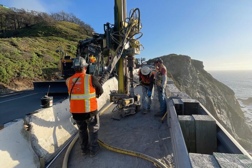
The work required drilling 40 vertical holes, all about 5 feet apart, in the existing roadbed, each 6 inches in diameter and 25 feet deep. Then, steel dowels were placed into the holes and encased with grout, essentially creating a steel curtain inside the rocky cliff.
Then crews drilled an additional series of holes in five rows that extended into the cliff almost horizontally. Steel rods and grout were also placed in these holes, further supporting the cliff, Turner said.
Their repair work, known as rock doweling, has been used to stabilize rock faces by “increasing shear resistance across failure planes,” Turner said.
The effectiveness of this repair “is in the grouted steel bars,” he said. “In order for the rock mass to shear, it would have to shear through these steel bars.”
To further stabilize the scarp, wire mesh was placed over the eroded cliff and sprayed with shotcrete — a form of concrete that will affix to the vertical wall of rock — to prevent loose rocks from sloughing off.
The challenging work was able to continue only during fair weather and was halted several times during storms and high winds.
A recent analysis of the slip-out near Rocky Creek Bridge determined that it was most likely caused by routine weather, erosion and water — common challenges along the Big Sur coast, which has repeatedly suffered through highway closures and unforeseen land movement, according to a new analysis by federal geologists.
Although such events are almost impossible to predict, officials said it’s good that a more precarious, deep-seated landslide doesn’t appear to be the cause of the March slip-out. That could result in ongoing and repeated issues.
More to Read
Sign up for Essential California
The most important California stories and recommendations in your inbox every morning.
You may occasionally receive promotional content from the Los Angeles Times.


