Why the 2017 fire season has been one of California’s worst
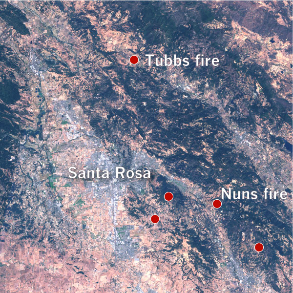
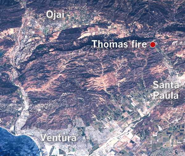
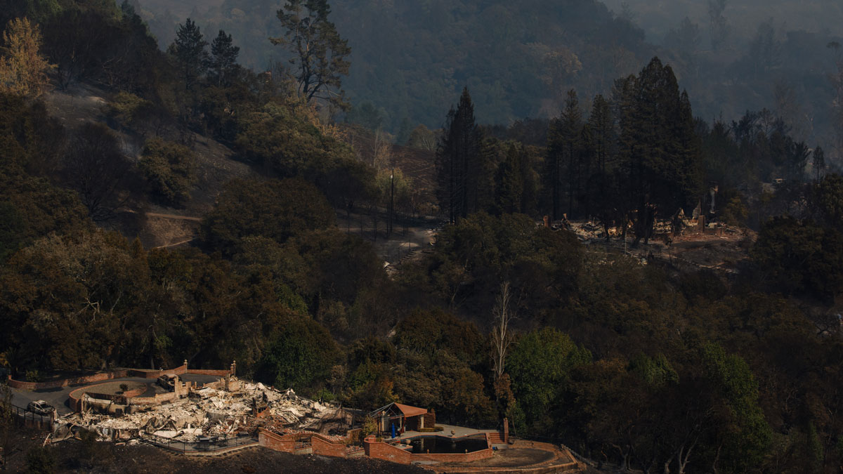
Wildfires that ravaged Northern California in October led to 44 deaths and the destruction of over 8,400 structures, including homes and businesses, making their mark as the most destructive wildfires in state history. On Dec. 5, the fast-moving Thomas fire swept into the city of Ventura, burning 50,000 acres and forcing 27,000 people to evacuate.
Here’s why California’s fall fire season has become so destructive — and why it could get worse.

Powerful winds, greater devastation
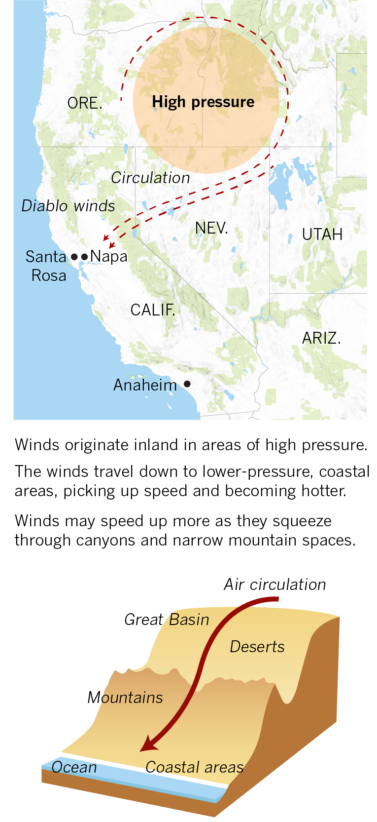
California is susceptible to fires year-round, but fires that occur in fall can be especially dangerous. The effects of hot, dry temperatures during the summer worsen in later months due to winds from the Great Basin. Known as Santa Ana winds in Southern California and Diablo winds in the north, these powerful warm winds cause fires to spread faster and quicker.
How these winds work

According to a 2015 study that examined fires in Southern California, wildfires occurring during the Santa Ana season — late September through the end of the year — cause far greater structural damage than fires in the summer. The ten most destructive wildfires in California's history all occurred between September and December.
Most destructive wildfires in California

The fires can be deadlier, too. Eight of the 10 deadliest fires burned during the fall season. The wine country fires in October were the deadliest in state history. There were 44 recorded deaths overall, with 22 deaths from the Tubbs fire alone.
Deadliest wildfires in California

A wet winter leading into a long, dry summer
Historic amounts of rain and snow in the winter kept large fires from burning in California until April. The 2016-2017 water year set records in the northern Sierra Nevada, which recorded a total of 94.7 inches of rain throughout the year.

While wildland vegetation grows every year during the wetter months, the heavy rains led to a larger amount of growth in areas like Santa Rosa and Napa, which hadn't seen large fires in several years. New brush growth is very flammable and can create embers that can travel a considerable distance.
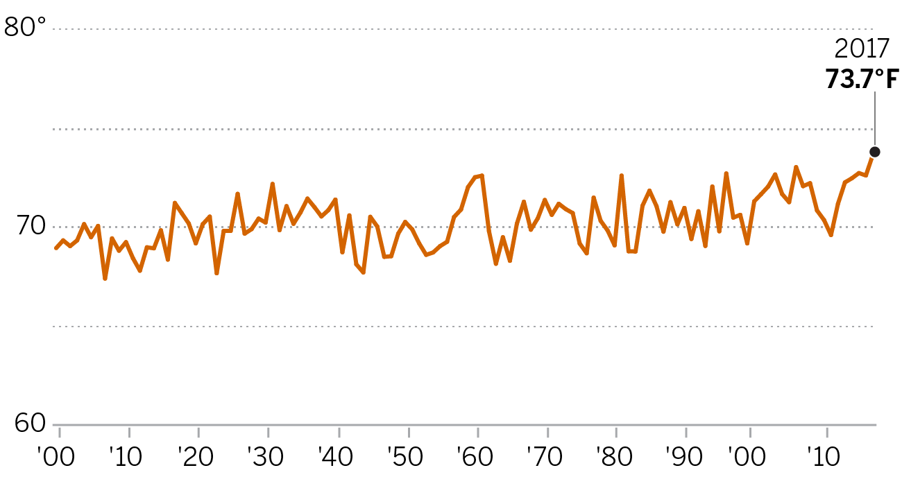
This summer was the hottest ever recorded in California, allowing for new vegetation to dry up.
Average summer temperature (June - August) per year in California
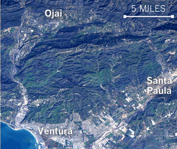
Composite images from the Landsat 8 satellite show just how dry the area around Santa Rosa had become after a recordbreaking rainy winter. In the first months of the year, record-setting rainfall led to increased vegetation in the area, but by summer, much of it had dried up.
January - March 2017
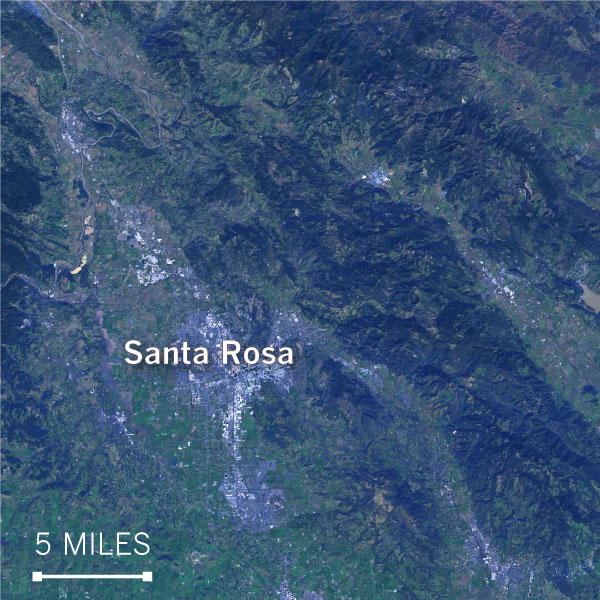
April - June 2017
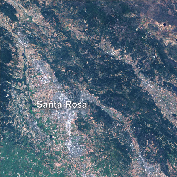
July - September 2017
The same is true of Ventura County, where the Thomas fire began on Dec. 5. Due to dry, fast winds and increased brush and vegetation the fire quickly spread, growing to 50,000 acres.
January - March 2017
April - June 2017
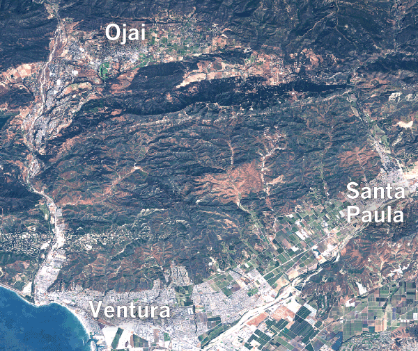
July - September 2017
“You kind of have this perfect storm of weather conditions,” said Yufang Jin, an assistant professor of remote sensing and ecosystem change at UC Davis, who co-authored the study on Southern California wildfires. Given these hot, dry conditions, Jin said, it’s not unusual to see more than 10 wildfires burning in a close area, much like the clusters of fires in Northern California this week.
As urbanization grows, so does the risk of wildfire
Over time, the edges of cities have encroached on wild spaces. The close proximity between private property and wildlands allows fires to spread more rapidly and damage or destroy more property in the process.
That allows fires during this part of the year to spread more rapidly into urbanized areas, Jin said.
Many of these at-risk areas are in wildland-urban interface areas, or WUIs — where housing and vegetation intermix or come within close proximity of each other.
Volker Radloff, a professor at the University of Wisconsin-Madison who works at Silvis Labs, describes some WUI areas as “like a medieval city, with an urban city next to a big dark forest.”
Some of the most heavily-damaged areas in the wine country fires in October were in the middle of these areas. The Thomas and Creek fires, currently burning in Southern California, also originated in or near areas where wildland and urban development mix.

Development in such areas poses a significant problem for firefighters and communities. According to a 2002 report by FEMA, 38% of new home construction in the western United States was adjacent to or intermixed with WUI areas.
“We could do better on land-use planning and how we build communities and where we place them,” said Scott Stephens, a professor of fire science at UC Berkeley. “In Northern California, there’s an underappreciation of communities’ vulnerability to fire.”
So what's next?
High-pressure-driven Santa Ana and Diablo winds can continue through the early spring, leaving an already dry state vulnerable to fast-spreading wildfires. Prescribed burns may not be effective in mitigating damage in areas with lots of low-lying grass and brush, where fire and smoke can spread quickly.

FEMA has listed several recommendations on how homeowners in WUI areas can protect themselves:
- Construct homes with fire-resistant materials.
- Situate homes on lots to protect them from fire spread.
- Clear a perimeter of defensible space around homes.
- Install smoke alarms.
- Develop and practice evacuation plans in the event of a wildfire.
Many of these recommendations must be acted on before a home is built, making it crucial for communities to work together to prepare for large wildfires, said Stephens. He recommends that homeowners in WUI or high-risk areas meet within their communities and with their local fire officials to make contingency plans before a wildfire.
Homeowners in high-risk areas can also remove flammable shrubbery from their yards and consider replacements such as aloe or ice plant — and look into purchasing fire insurance.
Credits: Paul Duginski also contributed to this report.