A thriving river, teeming with wildlife.
A future in which the city meets its own water needs without importing extra from elsewhere.
Can Los Angeles have both?
That’s the challenge facing a city that aspires to live within its environmental means.
If local agencies follow through on their most ambitious plans to capture more stormwater and reuse treated wastewater, the 51-mile-long Los Angeles River will probably dry up for a few months of the year, according to research from UCLA.
That, in turn, would kill fish and make the river less hospitable to the plants, birds and other wildlife that call it home.
“It’s going to be a tough tightrope to walk,” said Mark Gold, the environmental policy professor who led the UCLA study. “If we go all in on water recycling and stormwater infiltration and capture, then there’s not going to be enough water left for a thriving river.”
Steve Appleton, who co-founded LA River Kayak Safari five years ago, said it’s an issue he and others who use the river recreationally have been thinking about for some time.
“The UCLA study brings forward a really obvious set of contradictions,” he said. “We can’t come to the right conclusions if we don’t have a better idea of all the inputs and outputs.”
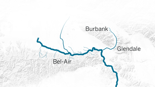
The L.A. River begins at the western end of the San Fernando Valley in the Santa Susana Mountains. From there, it cuts east until it reaches Glendale and then turns abruptly south, ultimately ending in Long Beach. It empties into the Pacific right near the Queen Mary.
As most Angelenos know, the river is not particularly scenic.
Most of the natural riverbed was paved after a massive flood in 1938 that killed 115 people. In the aftermath of that tragedy, the Army Corps of Engineers led the effort to create the deeply channeled, mostly concrete waterway that we have today.
“They built it for getting floodwater into the ocean as soon as humanly possible,” said Gold, whose research focuses on the environment and sustainability.
It worked.
Each year from 2003 to 2014, the river efficiently shunted an average of 274,000 acre-feet of water out of the metropolis and into the San Pedro Bay, the researchers said. That’s a bit more than half of the city’s water requirements for a year, the study authors noted.
An acre-foot of water is enough water to cover an acre of land one foot deep. A typical California household uses one-half to 1 acre-foot of water a year.
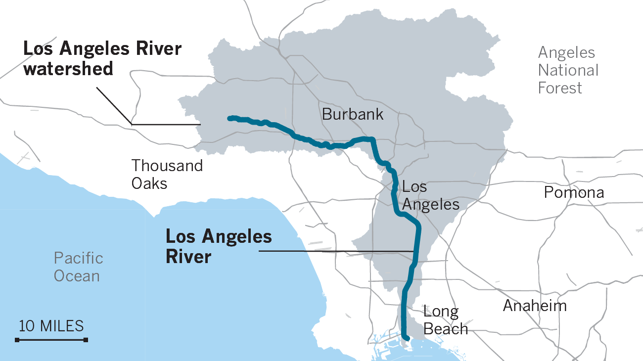
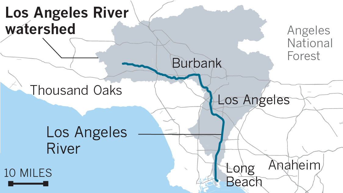
When it rains, the L.A. River is fed by an 825-square-mile watershed that encompasses parts of the Santa Monica and San Gabriel mountains, the San Fernando Valley, Vernon, Compton and Long Beach.
But when there hasn’t been a recent storm, more than 90% of the water flowing along its concrete bottom comes from three reclamation plants.
These plants take all the wastewater from apartment buildings, houses and commercial operations and cleans it.
Some of that water is used for irrigation at city parks and golf courses. Some feeds Lake Balboa.
But most of it — more than 30 million gallons each day — ends up in the river.
That might change.
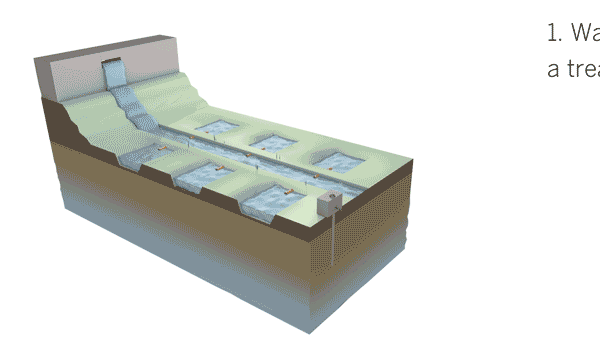
The Los Angeles Department of Water and Power is planning a large groundwater recharge project that is expected to move 30,000 acre-feet of treated wastewater into the San Fernando Basin each year. The treated water would be sent to spreading grounds there, where it would be absorbed by the porous soil and stored until city residents decided to pump it out.
In effect, it’s using the ground as a natural storage tank.
How spreading grounds work
Other plans are in place to build cisterns, rain gardens and vegetative swales — shallow, plant-covered channels — across the watershed that could divert as much as 130,000 to 170,000 acre-feet of water away from the river each year and put it into groundwater storage.
In addition, as Los Angeles residents embrace native plants and other forms of low-water landscaping, they’ll cut back on their sprinkler use. That means less runoff will reach the river.
“We know that if we do everything that is planned without being thoughtful and looking at all the impacts together, the minimum flows can get to zero,” said Katie Mika, a postdoctoral scholar at the Institute of Environment and Sustainability at UCLA who led the study.
The researchers noted that before the river was channeled and paved, there were probably times each year that parts of it dried up.
Even in the 1950s and ’60s — decades after the river’s transformation to a giant storm drain — flows in the river were about 10 times lower than they are today.
When the city was smaller, less of the area was paved and there were fewer people generating water runoff. There were also fewer water treatment plants serving this population.
But now humans have created a river that flows year-round, and an ecosystem of plants and animals has grown to rely on it.
For example, toward the end of the river channel in Long Beach, thin layers of water that run over the concrete have allowed algae to thrive. From early June to late September, this man-made algae lunch counter is so popular that as many as 10,000 shorebirds snack there each day, the UCLA researchers said.
If the river were dry, the algae would disappear, and the birds would have nothing to eat.
A concrete-channelized river may not sound like prime shorebird habitat, but as 90% of the region’s coastal wetlands have been lost, the birds have turned to the L.A. River.
It’s a balancing act that could take years to sort out.
Gold and Mika would like to see scientists figure out how much water the river needs to function as a habitable ecosystem.
Answering that question is likely to take years. For starters, researchers will have to define what that habitat should be — a thorny problem unto itself.
Ultimately, a seasonal water management strategy might provide the best compromise, Gold said. Perhaps the treated water could be used to irrigate parks and recharge groundwater for most of the year but help keep the river flowing during the dry summer months.
“There is way more water in the river than is needed right now for what’s lived there historically,” Gold said. “But how much is enough?”
Credits: Produced by Sean Greene and Priya Krishnakumar.
Credits: Lead photo by Mel Melcon. Produced by Sean Greene and Priya Krishnakumar.